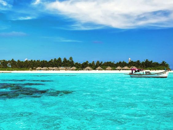
The smallest Union Territory of India in size is Lakshadweep. Lakshadweep is an island group of a total of 36 islands, which are well-known for their sun-kissed and exotic beaches as well as luxurious green scenery. The name Lakshadweep islands is in Sanskrit and Malayalam means “a hundred thousand islands”.
The smallest Union Territory of India in size is Lakshadweep. It is the smallest UT by geographical area, consisting of a group of beautiful coral islands in the Arabian Sea.
Key Facts: Smallest Union Territory of India
Name: Lakshadweep
Status: Union Territory of India
Area: 32 sq km
Capital: Kavaratti
Location: Arabian Sea (off the west coast of India)
Number of Islands: 36 (only 10 are inhabited)
With an area of just 32 square kilometers, Lakshadweep is not only the smallest Union Territory of India but also one of the most unique.
Why Lakshadweep Is the Smallest Union Territory
Lakshadweep is made up of tiny coral atolls and reefs. Unlike mainland Union Territories, its total land area is very limited, which makes it smaller than UTs such as:
Chandigarh
Puducherry
Dadra & Nagar Haveli and Daman & Diu
Geographical and Cultural Importance
Despite being the smallest Union Territory of India in size, Lakshadweep is famous for:
Crystal-clear lagoons
Coral reefs
Marine biodiversity
Eco-tourism
The majority of the population depends on fishing, coconut cultivation, and tourism.
Comparison With Other Union Territories (By Area)
| Union Territory | Area (sq km) |
|---|---|
| Lakshadweep | 32 |
| Chandigarh | 114 |
| Puducherry | 479 |
| Dadra & Nagar Haveli and Daman & Diu | 603 |
| Delhi (NCT) | 1,484 |

Smallest Union Territory of India:
Lakshadweep, the smallest Union Territory in India is an archipelago consisting of a total of 36 islands with a total area of 32 sq km. It’s a uni-district Union Territories, which has 12 atolls, three reefs, five submerged banks & ten inhabited islands.
These islands include an area of 32 sq km. The capital of this smallest Union Territory of India is “Kavaratti”. All Islands of the Lakshadweep are from 220 km to 440 kilometers away from the coastal town of Kochi in Kerala. The great quantity of flora and fauna, natural sceneries, sandy beaches, and the lack of a hurried lifestyle improve the charisma of Lakshadweep, the smallest Union Territory in India.
The islands of Lakshadweep are linked with regular air travel from Kochi. There is also a Helicopter transfer available from Agatti – Kavaratti all through the year.
April & May are the most sweltering with a normal temperature of 32° C generally the atmosphere is muggy warm and lovely. As the atmosphere is evenhanded during a rainstorm, dispatch based travel industry is shut. October to March is the perfect time to be on the islands.
From June to October, the South West Monsoon is dynamic with normal precipitation of 10-40 mm. The relative moistness is 70-75%. Yearly precipitation diminishes from South to North. On a normal, 80-90 days a year are stormy. Winds are light to direct from October to March
NOTE:
Lakshadweep has a steamy climate and thus it has a regular temperature of 27°C to 32°C.
Islands of Lakshadweep:

Agatti Island:
Agatti Island is 459 km (248 bunches) from Kochi, and it is situated west of Kaverthi Island. It is situated between 10 O 48 ‘and 10 O 53’ N scope and 72 degrees 9 ‘and 7’ 13 ‘E longitude, with a territory of 3.84 sq. km, with a limit of 10 km and width kilometers. In the south, there is a long-tail northeast, southwest pattern. The tidal pond region of this island is 17.50 km².
There are inexhaustible tidal ponds with cutting-edge coral advancement and multi-shaded coral fish. Angling is the most significant industry ahead time, which is likely the main island with the exception of Minaykoy where additional fish is found in the principal businesses in front of fisheries, coir, and copra. The port of Agatti is conveyed to the port of Bangaram, which can be seen on the northern horizon.

Amini Island:
Amini Island is 407 km (220 knots) from Kochi and is situated between Kawarati Island in the south and Kadmat Island in the north. This island has an oval shape, with a width of 1.20 km and a length of 2.70 km.
Corals and sandstones are used to build the purpose. The talented artisans living here are famous for making walking rods with turtle shells and coconut peels. It is also famous for stone engravers and is a rich tradition of folk songs. The island is called “Amin” to the Arabic word “Amin”

Andrott Island:
Andrott Island is the largest island with an area of 4.90 sq. Km, the length and maximum width of 4.66 km is 1.43 km. It is in the East-West direction, 10 ° 48 ‘and 10 ° 50’ N Latitude and 73 ° 38 ‘ Between 73 ° 42 ‘E longitude It is 119 km from Kawarati and 293 km from Kochi. This is the only island where there is a very small lagoon area.
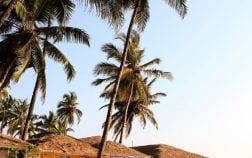
This is the closest island to the mainland and lays in a north-south direction, unlike other islands, a pre-west orientation. It is the largest island of Lakshadweep. Mainly add coconut trees bay trees, the beauty of the island. This was the first island to embrace Islam, St. Ubaydullah, the people of the islands who have been converted to Islam, died here and their tomb is still in Zuma in the mosque.
Religious preachers are held here in high esteem. The fishing industry is well developed, only after Minicoy and abduction. Core and Copra are the major products of the island.

Bangaram Island:
A beautiful and breathtaking island in Lakshadweep is Bangaram. It is surrounded by a shallow lagoon surrounded by coral origin. It has been ranked among the best in the world. Here, in the sun, sand and whitening, do a magic casting on the surf visitor.
It provides an extreme privacy policy with crystal clear water. The coral mural sparks and the blue lagoon do magic on a soul searching. A place where Hemingway makes a classic or van Goff will paint a masterpiece.
And who knows that muse may take inspiration to make even one, in parallel well-being, in a large 120-acre lush coconut tree in Bagram, beautiful fishes, tarpons, parrots, puffs, sweet feathers, and sea birds The search begins. There are many adventures such as scuba diving, beach sports, swimming, snorkeling, and deep-sea fishing.
The resort has 60-bird beach cottages, which include a multi-cuisine restaurant that offers numerous dishes. A well-stocked strip is also available. GATTI is the gateway to Bangaram and is connected to Cochin for the next flight to the metro.

Bitra Island:
Bitter Island is the smallest island in the area, with a total land area of 0.105 sq km. It has a length of 0.57 km and a width of 0.28 km wide. It is 483 km from Kochi. This island is located at 11 ° 36 ‘NI and 72 degrees 11’ E longitude. Although the land area is small, its lagoon area is 45.61 sq km
Bitra is the smallest island in the region. By 1835, there was a breeding ground for many Bitra sea birds, which was a favorite prey of Kalan and Chaitral people. Malik Mulla has a small pilgrimage place, which is an old Arab saint called the place of pilgrimage for people of other islands.

Chetlat Island:
Chetlat Island is 56 km north of Amni and 432 km (233 knots) from Kochi. It is located in the 1.40 km² area between 11 ° 41 ‘and 11 ° 43’ N latitude and 72 ° 41 ‘and 72 ° 43’ E longitude. Along with the eastern side of the island, there is a wide belt of the Coral Delta made of the storm, which spreads north and covers the entire southern end of the island.
Chetlat is the northernmost inhabited island. Turning the coir here is the capture of the thieves of the people. Coconut yield is poor and the income is weak. Matt’s export and weaving of coconut leaves are the industry of free time here. Portuguese hands in the 16th century. In the early 20th century, boat building was a prosperous industry, when all the ships of Amindivi Island were made here.

Kadmat Island:
The Kadmat Island is long and narrow, it is only 0.57 km wide and the maximum length is 11 km. It lies between 11 degrees 10 ‘and 11 degrees 16’ N latitude and 72 degrees 45 ‘and 72 degrees 48’ E longitude, in which a 3.20 square km area is located. This island is situated at a distance of 407 km (220 nautical miles from Kochi and is situated between Amini Island in the south and Chetlat Island in the north).
It has a lagoon on the west coast, which covers a distance of 2 km with a total of 37 km of the total area. The island is flat, 2 to 3 meters in the east and 2 to 4 m from sea level. Rising up in the west The high hills of the sand go down the western part of the island and there is also sand coagulation on the southern part of the island, which leads to insufficiency. The north is flat on the north.

Kalpeni Island:
One of the most wonderful islands of Lakshadweep is Kalpeni Island, which is arranged at a separation of 63 km from Androth. A significant spot for vacationer goals, Kalpeni offers sightseers with a brilliant chance to investigate their donning abilities and sportsman soul through the different water sports of the area.
For individuals who need an amicable mix of fun blended with an equivalent measure of experience, Kalpeni island presents them with plenty of bold water sports. Supplied with the best endowment of common and beautiful magnificence, the Kalpeni islands are an ideal mix of customary culture and present-day infrastructural civilities.

Kavaratti Island:
The Kavaratti Island is the home office of the smallest union territory of Lakshadweep. This island is at a separation of 404 km from Kochi and is situated between Agatti Island on the west and Andrott Island on the east. The most extreme length of the island is 5.8 km and the width is 1.6 km. It has a tidal pond having a length of around 6 km and a region of 4.96 sq. km.
The island is 2 to 5 m over the mean ocean level on the western side as well as 2m to 3m on the eastern side. It is situated in the focal point of the Lakshadweep archipelago. Abnormally Kavaratti has a little inland lake at its Northern end. The island itself is extended over a zone of somewhat more than 4 sq. km and has the most extreme level of non-islanders as inhabitants.

Kiltan Island:
It has a total of 3.4km in length as well as 0.6km in width at the widest point. On the northern and southern finishes of this island, there’re high tempest shorelines. This island is 213 nautical miles or 394 km away from Kochi. The aforementioned tidal pond region is 1.76 sq km.
Kiltan Island lies 51 km. north-east of the AMINI on the worldwide exchange course between Sri Lanka and the Persian Gulf. On the northern & southern closures of this island, there’s a high tempest beach. This island is dense in vegetation and is fruitful. The late spring evenings in Kiltan are hotter and it is normal for the general population to rest outside their homes, on the shorelines.

Minicoy Island:
Minicoy Island is the second biggest and southernmost island in Lakshadweep; the bow formed and has probably the biggest tidal pond. Minicoy is separate from the Northern gathering of islands by its way of life. The nearest land to this island is Thuraakunu Island in the Democracy of the Maldives about 100 km toward the south over the Vangaaru Channel.
Every town is going by a Bodukaka and a Bodudatha helped by a second Bodukaka and a second bodudatha. First Bodukaka takes care of the interior issues of the town and second Bodukaka the outside issues.
A townhouse is where ‘Baemedu’ (Assemblage of residents) is held. As a wellspring of salary, a town has angling vessels, nation specialties, and coconut trees. Regular blowouts are directed at the townhouse during the festivals of Eid and other bubbly events.
FAQs:
Q. Which is the smallest Union Territory of India by area?
A. Lakshadweep is the smallest Union Territory of India by area.
Q. What is the total area of Lakshadweep?
A. The total area of Lakshadweep is 32 sq km.
Q. What is the capital of Lakshadweep?
A. The capital of Lakshadweep is Kavaratti.
Q. Is Lakshadweep the smallest UT by population also?
A. Yes, Lakshadweep is among the least populated Union Territories of India.
Q. Where is Lakshadweep located?
A. Lakshadweep is located in the Arabian Sea, off the western coast of India.
Q. How many islands are there in Lakshadweep?
A. There are 36 islands, out of which only 10 are inhabited.
Conclusion:
The smallest Union Territory of India in size is Lakshadweep, covering just 32 sq km. Though small in area, it is rich in natural beauty, marine life, and cultural uniqueness. Lakshadweep stands as a perfect example of how even the smallest regions can hold immense importance for a country.
